African Archaeology Lab
Visit our Lab Website for more information on the Museum's collection of archaeological and ethnographic material residues of the African continent. Our collection contains more than 6,000 artifacts from across Africa.
Adaptations to Marginal Environments in the Middle Stone Age (AMEMSA)
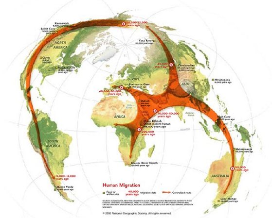
This project aims to understand where, when, how, and under what environmental conditions modern humans developed the capacity for such remarkable adaptive plasticity. This plasticity is perhaps best exemplified by our species’ rapid series of dispersals from the African continent between ~100,000 and 60,000 years ago. Within perhaps as little as 10,000 years after leaving Africa, our species managed to colonize and operate competently in virtually every major biome on earth—from the dense rainforests of Southeast Asia to Papua New Guinea’s rugged highlands to the extreme deserts of Australia. Just how they were able to do this is being revealed by ongoing archaeological research along the so-called “southern route” (Oppenheimer 2009) by which modern humans first successfully dispersed from Africa following the southern coastal margins of Asia. The evidence shows that these pioneers possessed the ability to rapidly generate ingenious solutions for surviving in diverse, alien, and often very challenging ecologies. The very speed and fluency of these dispersals suggest to us that this aptitude for adaptive flexibility did not develop “on route,” but rather was born of longer-term selective pressures exerted within Africa itself.
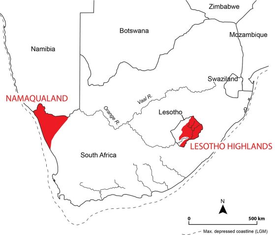
To explore this, project AMEMSA investigates human responses to challenging habitats in southern Africa. These are important analytical settings because they pose resource stresses and logistical challenges that demand flexible, creative solutions. The timing, pace, and modes of their colonization within Africa can thus help us understand the cultural evolutionary development of resilient behavioral systems typical of modern foragers, such as expansive social networks. Southern Africa is an ideal research area to explore the question of adaptive flexibility due to its tremendous ecological diversity, which includes marginal settings, and its high-quality Cape coastal MSA archaeological record to which comparisons from these less equable settings can be drawn. AMEMSA targets two such settings: (1) the inland, high-altitude grasslands of eastern Lesotho and (2) the sub-arid coastal desert of Namaqualand, South Africa.
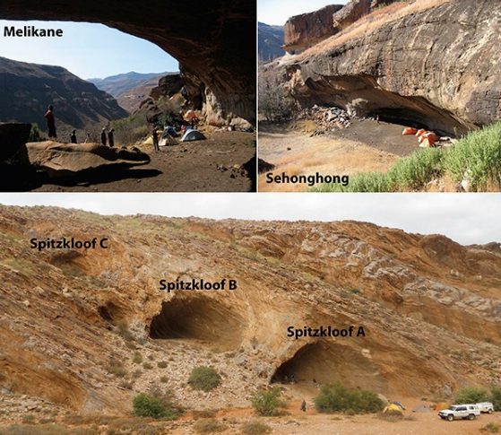
The project consists of two phases, the first of which is underway and laying the groundwork for the second. In the first phase, targeted excavations are being conducted at significant rockshelters with deep Late Pleistocene sequences: Melikane, Sehonghong (both in Lesotho), and Spitzkloof (a series of three adjacent rockshelters in Namaqualand). The Lesotho sites have highly significant, pulsed sequences spanning the last 85,000 years (Stewart et al. 2012). The Spitzkloof rockshelters are still under excavation, but thus far 60,000-year-old levels have been encountered that overlie even older deposits (Stewart & Dewar 2012). Having established robust, detailed archaeological and paleoenvironmental records for both regions based on these sedimentary sequences, the second phase will greatly expand the sphere of investigation to incorporate the rich archaeology and geomorphology of the surrounding mountain and desert landscapes. Unusually high densities of open-air MSA lithic scatters and (in Namaqualand) shell middens, along with rich paleoenvironmental repositories in the form of sediment exposures, have been identified in the vicinities of each of the rockshelters studied to date. Relating the data from these open-air locales to the excavated rockshelter cultural and paleoenvironmental frameworks will provide a rare opportunity to enlarge the lens of MSA enquiry from its traditionally restricted window of the archaeological trench to the broader, shifting marginal landscapes in which our ancestors “cut their teeth” before encountering the full range of global ecosystems beyond Africa. In the process, the second phase will provide fundamentally new insights into how that spread was made possible.
The project involves the tight integration of multiple archaeological and paleoenvironmental proxy data generated from both excavated and open-air situations in order to understand how early modern humans spatially organized themselves to optimally exploit high-altitude grasslands and semi-arid desert. With my project co-director, Genevieve Dewar (University of Toronto), I have assembled and coordinate a team of specialists from the UK, USA, Canada, South Africa, and Australia to analyze and integrate diverse datasets from these sedimentary sequences, incorporating: chronological (AMS 14C, single-grain OSL); geoarchaeological (sedimentology, micromorphology); paleoenvironmental (charcoals, phytoliths, pollen, isotopes, sedimentology); subsistence (fauna, macrobotanicals); and lithic typo-technological and functional evidence. In the broadest sense, the rockshelter results suggest that, although occupations in these settings were strongly pulsed, in each region there is a marked change from sporadic to more intensive occupational episodes. As such, we are revealing something of the very processes by which later Pleistocene Africans were mastering the specific challenges of these habitats.

The second phase of the project will take this work a crucial step further by widening our understanding about group mobility patterns and adaptive responses in the open landscape itself. With this phase, we will conduct off-site archaeological surveys along with geomorphological surveys aimed at both reconstructing landscape evolution and developing continuous, high-resolution later Pleistocene paleoenvironmental sequences from sediment exposures. The positions and compositions of all MSA lithic scatters, quarry sites, and (in Namaqualand) shell middens will be recorded with high precision Differential Global Positioning System (DGPS) units using fixed, ground-based reference stations, and spatial analyses will be performed using an integrated relational/GIS spatial database. Late Pleistocene-age colluvial/paleosol and alluvial sediment exposures, which abound in both areas, will be sampled using vertical sediment columns and diverse paleoenvironmental analyses performed on pollen, spores, phytoliths, plant macrofossils, and sediment compositions and isotopic signatures. These open-air datasets will then be related to the dated rockshelter sequences using comparative typology for the lithic scatters, and radiometric dating for the shell middens (14C) and paleoenvironmental sediment exposures (bulk 14C and OSL). Research on this crucial period of human evolution can thus begin to move from the static, site-specific investigations that currently predominate toward more dynamic reconstructions of early modern human subsistence-settlement systems set against robust regional paleoenvironmental frameworks.
Context and Controls on Modern Human Behavior in Southern Africa: Human-Environment Interactions in the Late Pleistocene
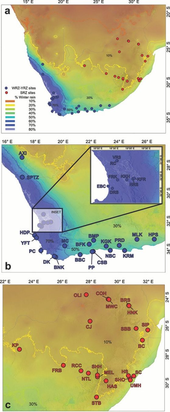
I am a member of an INQUA-funded project that brings together young specialists in southern African prehistory to assess the factors responsible for the advent of complex, “modern human”-like behaviors on the subcontinent. Recent research is making it increasingly clear that the earliest expression of behaviors characteristic of modern human hunter-gatherers, such as complex technologies and material symbols, was not a sudden or even linear event. Rather, these behaviors sporadically emerge and disappear like a flickering switch throughout the African late Pleistocene. What caused this erratic signal, however, is currently unknown. A number of hypotheses have been put forward variously identifying dietary shifts, environmental changes, or human demographics as prime movers. But these or indeed other hypotheses are currently extremely difficult to test for various reasons, including: (1) a lack of a cohesive paleoenvironmental framework for Late Pleistocene southern Africa; (2) poor quality and resolution of much archaeological data; (3) little consistency within and between archaeological and paleoenvironmental datasets; (4) a dearth of communication or collaboration between researchers specializing in different areas of the subcontinent; and (5) a lack of theoretically robust model building. This project is designed to address these shortcomings by generating a forum for young researchers to share, integrate, and jointly analyze disparate paleoenvironmental and archaeological data from throughout southern Africa.
More specifically, the project aims to:
• “Build a detailed picture of environmental change in southern Africa through the late Pleistocene based on the most recent evidence available,
• Map the various forms of archaeological data (e.g. faunal, technological and symbolic streams) onto this environmental baseline, and,
• Explore the relationships between various data sets and environmental contexts in order to understand causation and correlation in the appearance of behavioural complexity” (INQUA HABComm website: http://www.inqua.org/habcom/projects/ChaseB.html, accessed 4/23/14).
The first outcome is an article in Journal of Human Evolution (Mackay, Stewart & Chase, in press). Our central argument is that the conspicuous periods of enhanced behavioral innovations apparent in Marine Isotope Stage (MIS) 4 (Still Bay and Howiesons Poort) and MIS 2 (Robberg) do not stem from increases in effective population size, but rather from enhanced population interconnectedness. Interconnected populations are likely to have diffused novel fitness-enhancing information more rapidly than weakly connected populations, providing adaptive advantages. Interconnected populations may also have been more resilient, diminishing the frequency of local population extinctions. Furthermore, it has been argued that population interaction was a particularly relevant variable in the production of personal ornaments and identity markers.
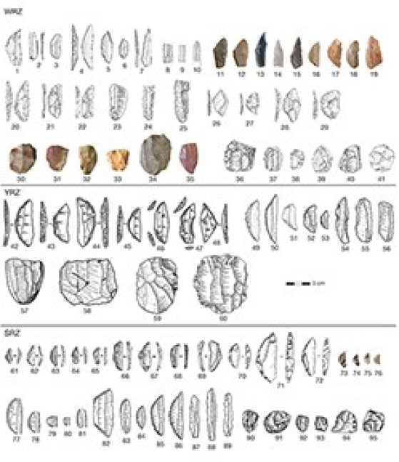
We support our position by examining pan-southern African trends in lithic provisioning systems, raw material selection, flaking systems, and implement types through the period ~130–12,000 years ago, and employing cultural transmission theory to interpret the data. Our analysis reveals that both information transmission between groups and environmental conditions were clearly important factors in generating previously identified patterns, but the extent of their influence varied through time. Widespread population interaction is apparent at various times, and most especially in the Still Bay, classic Howiesons Poort (both MIS 4), and Robberg (early MIS 2). During these periods we identified between-region similarities in flaking systems and implement types, and also material selection within the constraints of local/regional geology. Socially transmitted similarities in technology appear to have “overridden” traits adapted to local environments. These periods of interregional population interaction also correlate with periods in which ornaments and symbolic items become common in the archaeological record. This provides a relatively parsimonious and theoretically grounded explanation for their complex temporal distribution, and one that does not rely on forces that are difficult to detect archaeologically. Outside of MIS 4 and MIS 2 (i.e., MIS 5 and 3), there appears to be strong evidence for fragmentation of populations, with technological traits yielding a strong signal of local adaptation. We will continue this innovative research with further papers aiming to disentangle the complex causal factors behind these diachronic trends of coalescence and fragmentation.
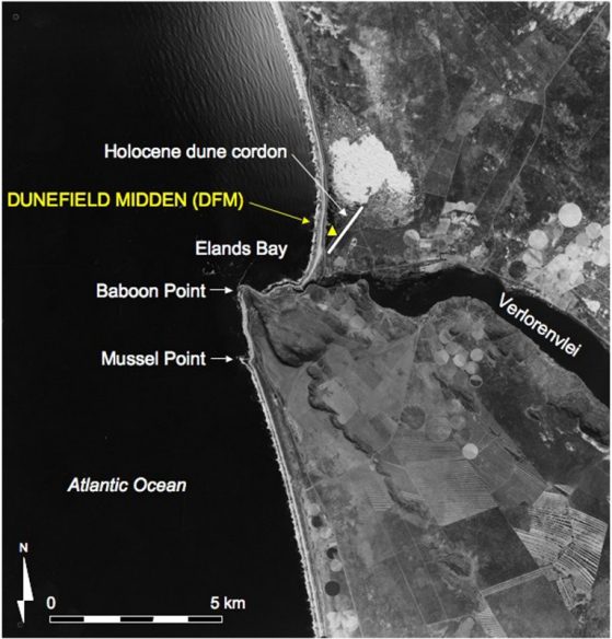
Later Stone Age Spatial, Subsistence and Social Organization at Dunefield Midden, South Africa
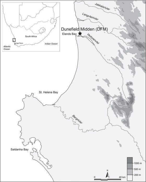
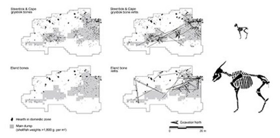
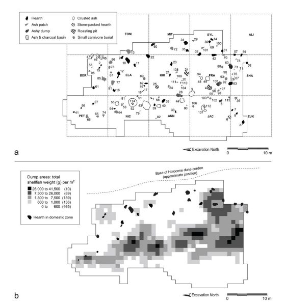
This ongoing research stems from my PhD, for which I performed a comprehensive intrasite spatial analysis of diverse archaeological materials from Dunefield Midden (DFM), a late Holocene Later Stone Age (LSA) coastal campsite in the Western Cape Province, South Africa. The site is virtually unique in southern African archaeology because it consists of a single stratigraphic layer or “living floor” with only limited overprinting in restricted areas. Features are abundant (n = 114) and include hearths, roasting pits, ashy dumps, ash patches, stone-packed hearths, crusted features, and ritual small carnivore burials. The site is structured into a domestic zone with abundant hearths adjacent to a main dump with an intervening area of relatively low artifact density. The lack of vertical stratigraphy has enabled excavations to extend horizontally to a considerable degree, uncovering some 860 m2 of in situ deposits. DFM is thus one of the very largest excavated Paleolithic campsites in the world. I applied the technique of refitting to ceramics, ostrich eggshell fragments (from water flasks), and bones from several taxa of fauna—eland, sheep, steenbok, and tortoise. Intrasite connections are explored with the aid of an integrated relational GIS research database. Ethnoarchaeological data are employed to formulate hypotheses with which to explain the observed spatial patterning of remains. Interpretation is further facilitated by integrating the spatial analyses with data from technical and faunal examinations of the materials themselves.
My PhD research resulted in a detailed spatial reconstruction of on-site subsistence organization. Activity areas implicated in carcass processing, cooking, disposal, and even sharing were identified using ethnoarchaeologically derived methods. A number of animal carcass processing and disposal behaviors were identified for the first time in a southern African archaeological context. The evidence for these behaviors, along with the intensity of secondary disposal at the site, seriously calls into question whether the Kalahari is an appropriate supplier of analogs for the LSA. A related issue is the identity of the site’s inhabitants. Though still unconfirmed, I have argued that the group(s) responsible for depositing DFM were either pastoralists without livestock or coastal-dwelling hunters-with-sheep with close economic, social, and perhaps even ritual ties with more fully dedicated pastoralist groups sharing the Western Cape landscape. This is assessed by integrating the refitted ceramic and sheep assemblages with data from previous studies of the site and ethnohistoric observations.
When combined with ethnographic, ethnoarchaeological, and ethnohistoric observations, this “across the board” refitting and spatial comparison has the potential to expose patterns in DFM’s inhabitants’ organization of domestic space and, by extension, enable an unusually detailed understanding of key elements of their social structure. The ultimate aim of the research is to deconstruct the spatial palimpsest of cyclical events—hunting and gathering/slaughtering; processing; sharing; cooking; disposal/cleaning—into individually intelligible, articulated segments of a daily subsistence sequence. This can afford a rare glimpse at prehistoric people in their daily routine, thereby putting a refreshing and no doubt healthy dose of anthropology back into archaeology.