This year during Esri’s 41st annual User Conference, the University of Michigan was awarded their most prestigious award, the President’s Award, by Esri’s founder and president, Jack Dangermond. This is the first time a university has received this recognition. Receiving the award on behalf of the university was LSA Technology Services’ very own Peter Knoop, Research Computing Consultant, from the Research Computing and Infrastructure team. Joining Knoop at the virtual conference and award presentation were his colleagues, Caitlin Dickinson and Abbey Roelofs. View the Award Video.
The university has been an early adopter since 2012 when ArcGIS Online was first released. It was implemented as Software-as-a-Service making it readily available to everyone and allowing it to become as ubiquitous as Microsoft or Google products. GIS offers a wide range of solutions that consists of easy-to-use web and mobile applications such as ArcGIS Online, StoryMaps, and Survey123, to more advanced, powerful desktop applications such as ArcGIS Pro. Knoop indicated that nearly every LSA unit or department is using GIS in some form. He shared, “A sign of success is that we don’t always know what people are doing, unless they ask for help. It has become easy enough that people are trying it out themselves.”
The wide-spread adoption of GIS across LSA is the product of LSA Technology Services partnering with a variety of faculty on innovative GIS projects, and from those efforts developing best practices to share with other faculty facing similar needs. Knoop has played a huge role in the implementation and advancement of GIS at U-M. He and his colleagues have devoted a lot of time and effort providing GIS support, offering workshops and webinars, and sharing best practices and lessons learned both with U-M faculty and staff, and the greater academic community.
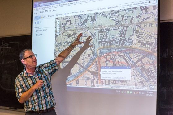
Using a historic map of Berlin (1910) in an ArcGIS Online, Shachar Pinsker presents information in an appropriate spatial context for the time period being discussed.
In 2014, Knoop worked with Shachar Pinsker (Judaic Studies) to pioneer the use of StoryMaps in Digital Humanities courses. Pinsker developed an assignment that helped students understand the spatial relations of cafés and their key roles as centers of political, financial, scientific, and literary exchange in the late 19th and early 20th centuries (see A Digital Map of Historical Cafés.)
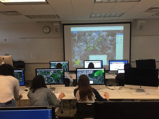
Students in EARTH 380 using GeoPlanner for ArcGIS to apportion solar power arrays across university-owned land and structures to meet a 500GWHr per year production goal.
In 2017 Adam Simon (Earth and Environmental Sciences) and Knoop were awarded the Provost's Teaching Innovation Prize for Mapping Possibilities for U-M’s Energy Independence. They developed weekly modules using GeoPlanner for ArcGIS to engage students in a semester-long project exploring alternative energy options for the university's electricity supply from a unique, spatial perspective, anchored in realism. The project culminated in students' authoring StoryMaps to present their results to a fictional audience of university stakeholders. As one student noted, "Rather than using discussion sections in the traditional manner - to review material, have discussions, take quizzes, or answer questions - students conduct projects to directly assess the feasibility of transitioning our campus from fossil fuel based to renewable energy sources."
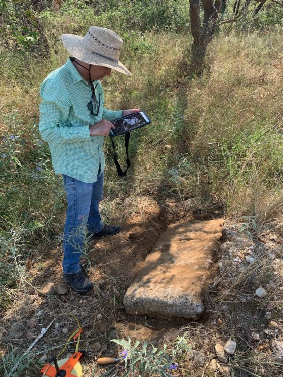
David Stone recording data on an archaeological find using an ArcGIS field app at Olynthos, Greece.
Kacey Lohman (Earth and Environmental Sciences), Simon, and Knoop have also collaborated over the years with Esri to develop and deploy GIS apps for use in the field. The three have incorporated these apps in a variety of geology field trips, which serve as an ideal test-bed for putting new technology in the hands of students, under conditions where if it fails, the education goals of the trip are not adversely affected. From there, Knoop worked with Chris Rate and Lisa Nevett (Classical Studies) in applying the technologies that proved useful and sustainable to archaeological field research projects at Notion,Turkey and Olynthos, Greece; failure not being an option for these projects, Knoop accompanied these research teams into the field to provide on-site support and troubleshooting when things didn't go right. The end result ultimately being the development of best practices for GIS in field research in general, which have been readily adopted by others across LSA.
Congratulations to Knoop, his fellow GIS colleagues, and the university for a well-deserved achievement.
To learn more about ArcGIS and LSA GIS consulting, please contact LSATechnologyServices@umich.edu to arrange an appointment with a GIS Consultant to discuss your needs.
Additional U-M GIS Resources
GIS at the University of Michigan — A good starting point for learning more about the GIS resources available to you at the University of Michigan.
U-M GIS Community of Practice — A venue for members of the campus community to share information, experiences, and ideas around GIS topics
Installation and Licensing Instructions for ArcGIS — A self-help resource for installing, licensing, and using various desktop Esri ArcGIS applications.